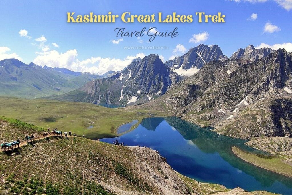
When you think of Kashmir, your eyes visualize a canvas of endless meadows and alpine lakes with cobalt-blue waters nested amidst high-altitude mountains. Rightfully, Kashmir cherishes the title, ‘Paradise on Earth’. Well, it’s really a paradise with manicured carpets handcrafted by the Creator. Trekking to the Kashmir Great Lakes (KGL) is an adrenaline-rushing activity for all adventure lovers.
Kashmir Great Lakes Trek Overview
About KGL Trek
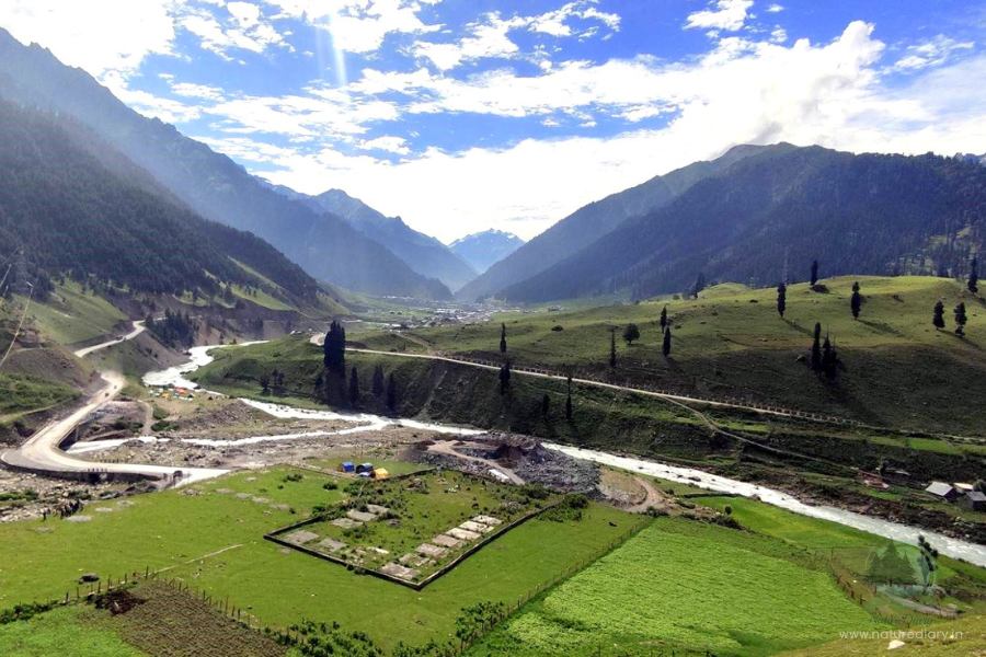
Kashmir Great Lakes is one of India’s most picturesque treks that remains open from July to September. The sprawling meadows and jagged mountains remain inaccessible for the rest of the year due to harsh weather conditions and snow. Located to the northeast of Srinagar, it lies 75 Km away from the capital.
What makes the KGL trek special is its versatility with landscapes. The 7-day trek covers more than 75 Km distance and takes you through rolling meadows, tricky boulder zones, steep climbs, and descents. The lakes are named after Gods, and the blissful trek route through the paradise on earth rightfully justifies its stature.
Kashmir Great Lakes brings you a very different terrain each day. You have five different valleys and at least six lakes to explore. Starting from Sonmarg and finishing at Naranag, the high-altitude trek (the highest point at Gadsar Pass: 13,800 feet) is not for beginners. The trek route is moderate to tough, but the key challenges remain the long routes and sun-breathing fire overhead. While temperatures range between 7 to 19 degrees C in July, the extremely steep climbs can take a toll if you aren’t prepared.
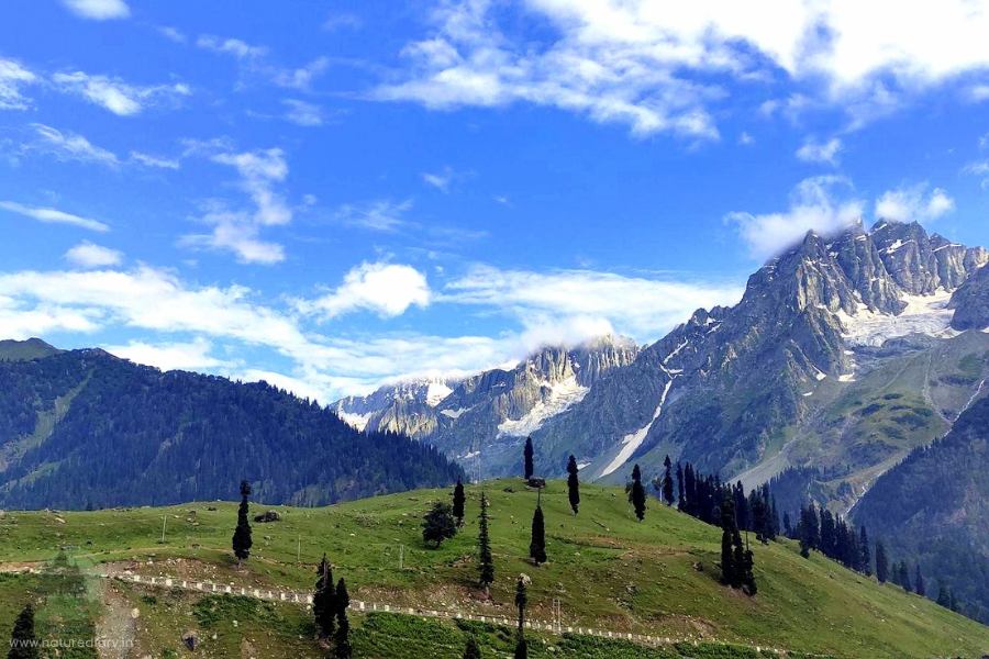
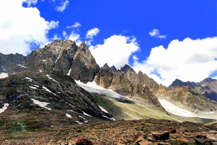
Scattered throughout the trek route, you would find snow patches feeding the picturesque glacial lakes. They sometimes slide along the mountains into the blue-green waters. Icebergs, meadows, and unpredictable boulder zones make the KGL trek truly diverse.
Well, you might live the wallpaper lifestyle for seven days, but I bet you cannot let go of the charismatic sensation when you are back. And then, you have the adrenaline rush when you cross the three high-altitude passes: Nichnai Pass, Gadsar Pass, and Zaj Pass. So, if you are yet to conquer this trek, it’s time to start planning!
The Mythology of Kashmir Great Lakes
Most of the lakes you would trek in the Kashmir Valley are named after Hindu Gods. Besides, on the 6th day of the KGL trek, you would descend to Gangabal Campsite. In the backdrop amidst the mountains, you can spot Mount Harmukh, which means ‘The Face of God’.
As per local mythology, Lord Shiva resides on the top of this mountain. Although the mountain has a height of 16,000 feet, Mount Harmukh has remained unconquered to date. It’s believed that the ruggedness of the terrain and challenges due to extreme climatic conditions prevent mountaineers from scaling the peak.
Once, an ascetic continued to resist the harsh conditions and tried to climb the mountains. His efforts continued for 12 years but failed to get to the top. Ultimately, he disappeared after attaining nirvana. However, people can climb this mountain up to 14,000 feet every year. A pilgrimage takes place where local villagers climb up to this height to offer their prayers to Lord Shiva.
It was in 1856 that the first expedition to Mount Harmukh took place under Thomas Montgomerie as a part of the Great Trigonometric Survey. Interestingly, the expeditors ended up discovering K2, the second-highest peak in the world after mount Everest, during this expedition!
Highlights of Kashmir Great Lakes Trek
- Altitude: 13,800 feet (Highest Point)
- Trekking Difficulty: Moderate to challenging
- Starting Point: Sonmarg
- End Point: Naranag
- Distance Covered by Trekking: 75-80 Km
- Duration Of Trek: 7 days
- Temperature: 7°C to 20°C during the day and 2°C to -4°C at night (July–September)
- Rainfall: Moderate chances during the period
- Best Time To Visit: The trek remains open only for 3 months (July–September)
- Nearest ATM: Srinagar
- Nearest Airport: Srinagar
- Nearest Railway Station: Jammu Tawi
- Mobile Network: Only postpaid sims work in J&K. No network is available throughout the trek once you cross Sonmarg.
- Cost of Trek: ₹12000 to ₹15000 per head (Including accommodation costs, food, and charge for the guide).
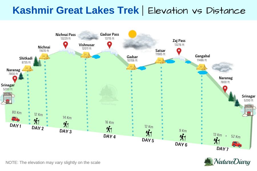
KGL Trek Elevation Map
How to Reach Kashmir Great Lakes from Srinagar?
It would be wise to fly directly from your respective city to Srinagar for trekking to the Kashmir Great Lakes. Travelling via rail to Jammu can delay your plans as the highway connecting Jammu and Srinagar (300 Km) experiences frequent landslides during the monsoon months.
So, you can schedule a flight to reach Srinagar in the morning. Therefore, you can start your journey towards Sonmarg on the same day without staying at Srinagar overnight. However, you need to consider a buffer day during the trek to make room for uncertainties like incessant rainfall.
Also, trekkers might need to rest for a day in the middle, considering that the difficulty level is moderate to high. Therefore, you must book your return flight from Srinagar on the 9th day. Under ordinary conditions, it would be wise not to use the buffer day unless necessary.
Kashmir Great Lakes Trek Routes
There is only one Trek route when you explore Kashmir Great Lakes. Most importantly, once you set your path, there’s no easy exit point. The most common route is to drive from Srinagar to Sonmarg and reach Shitkari, where you can pitch your camps on the first day. However, some trekkers drive from Srinagar to Naranag and then to Sonmarg before starting to take on the trails. After crossing the lakes and valleys for seven days, the trek ends at Naranag.
Kashmir Great Lakes Trek Itinerary
Day 1 (Drive from Srinagar to Sonmarg and reach Shitkari campsite)
- Distance: 80 Km
- Drive time: 2.5-3 hours
- Altitude: 7800 ft.
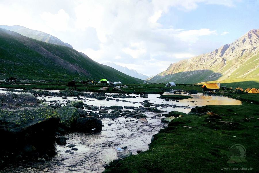
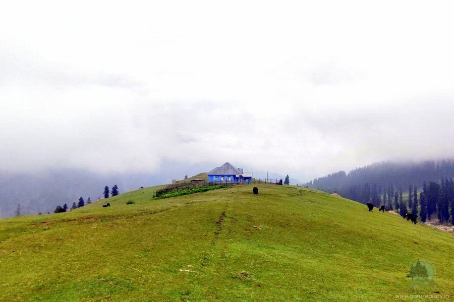
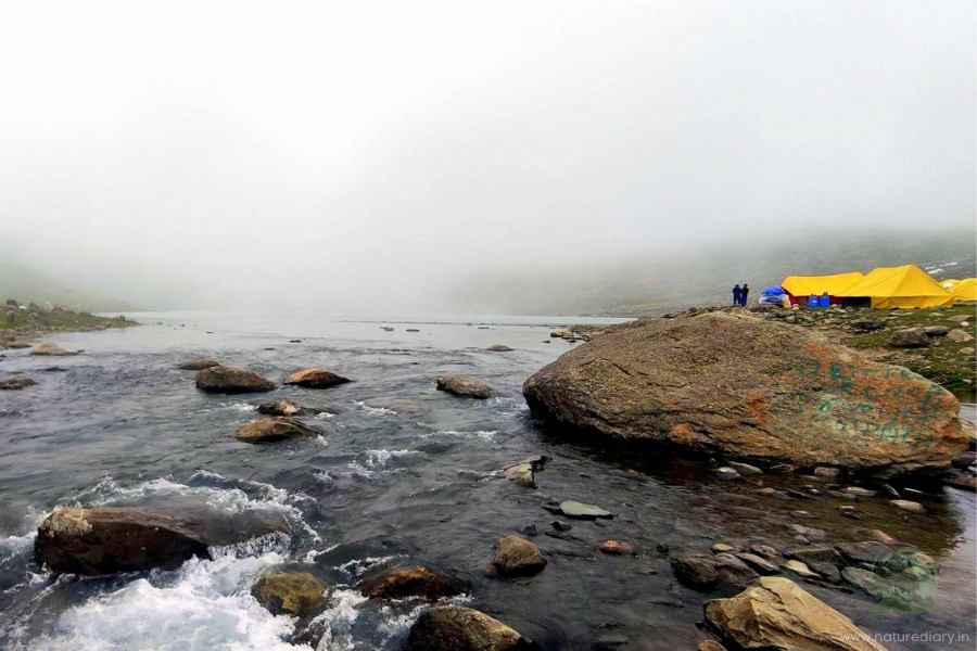
Sonmarg camping is one of the best camping places in India for its picturesque view, weather and facilities. While the actual trek to KGL starts from the Shitkari campsite at Sonmarg, there’s no need to walk on the first day. You need to drive from Srinagar to the campsite, the last fringes of civilization, where cars can access the road. The mighty Sindh river traverses sonorously through the valley just beside the picturesque camp.
Starting your journey at noon, you can reach the campsite by 3 pm. It would be wise to use the rest of the day to familiarize yourself with the trails and trek conditions. In Kashmir Valley, the sun sets around 8 pm. So, the days are pretty long, which provides plenty of time for trekkers to prepare their dinner and get their tents ready.
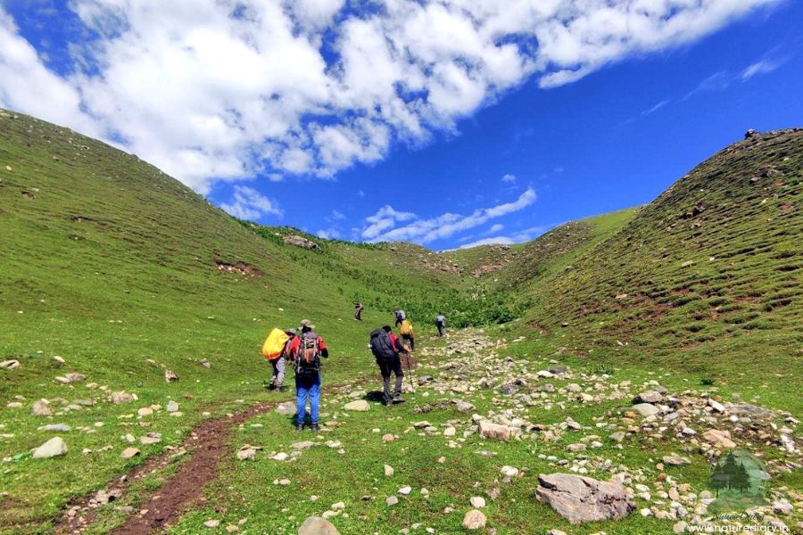
Day 2 (Trek from Shitkari Campsite to Nichnai)
- Distance: 12 Km
- Trek time: 7 hours
- Altitude gain: 7800 ft. to 11607 ft.
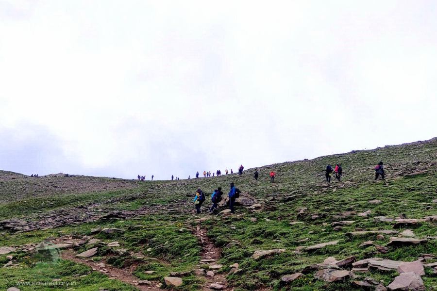
Leaving behind the Sindh river and the jeep track close to the campsite at Shitkari, a mud track elevates high into the mountains. This is the trail you need to take that would lead to the second day’s destination Nichnai.
You would be gaining altitude quickly for the first three hours. While there’s a sharp descent along this trail for the next hour, you would enjoy a pleasant ascend to Nichnai for the last couple of hours.
After trekking for 15 minutes of starting at 8:30 in the morning, you would find a left turn, giving way to a serene green meadow. Below, you can spot the first campsite overlooking Sonmarg town.
Then you have to trek for 1-2 Km and you would come across a flat ground where the Indian Army would check your credentials and collect photocopies of your ID card. These formalities during the Kashmir Great Lakes trek might take around half an hour, depending on the size of your team.
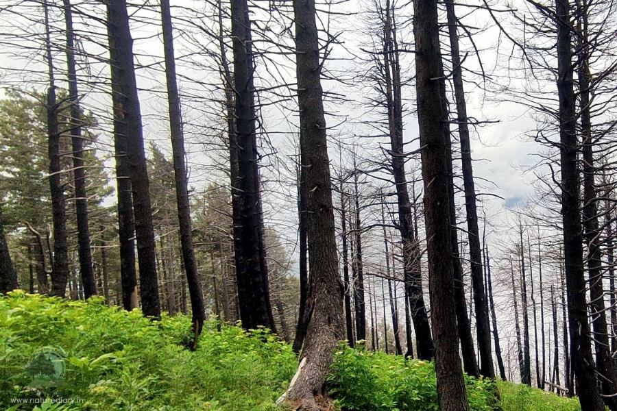
Next, you would find the Pine and Maple forests sprouting along the green carpet. While you cherish the rolling meadows at your feet, the splendid canopy of the Maples would define the typical beauty of Kashmir. This forest ends at the top of the ridge, and you will get a view of the narrow river snaking through the valley.
It’s time for descent after a hectic climb! Looking back, you can catch one last glance at the picturesque Sonmarg valley with all its greenery. On the front, the meadow shows the way down, along with pines and the rugged river valley.
Marching amidst Silver Birches and scattered huts of the shepherds, the middle trail through the forest would lead your way down. Along the way, you can spot thick foliage with the sun rays peeking through the leaves.
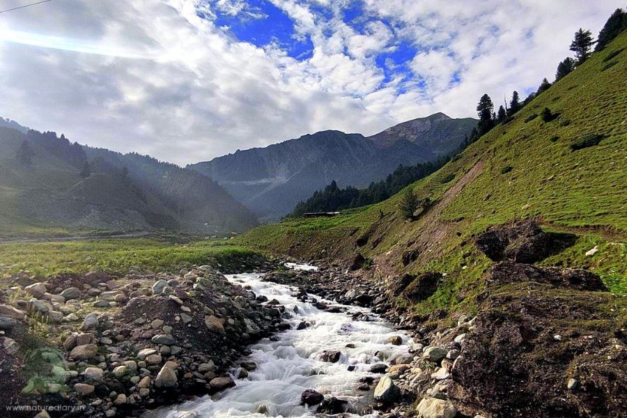
Trekking along the river valley boulders would test your skills; trails would frequently show up later in the trek.
The view around the river valley would be quite different from what you had witnessed so long amidst the meadows. The snow-capped peaks stand as ever-alert sentinels, with the mountains blocking the access to the green valley you just crossed. With mules showing up frequently along the path, your progress along the river valley would be a sloth.
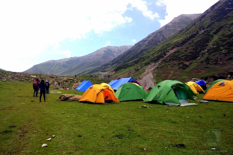
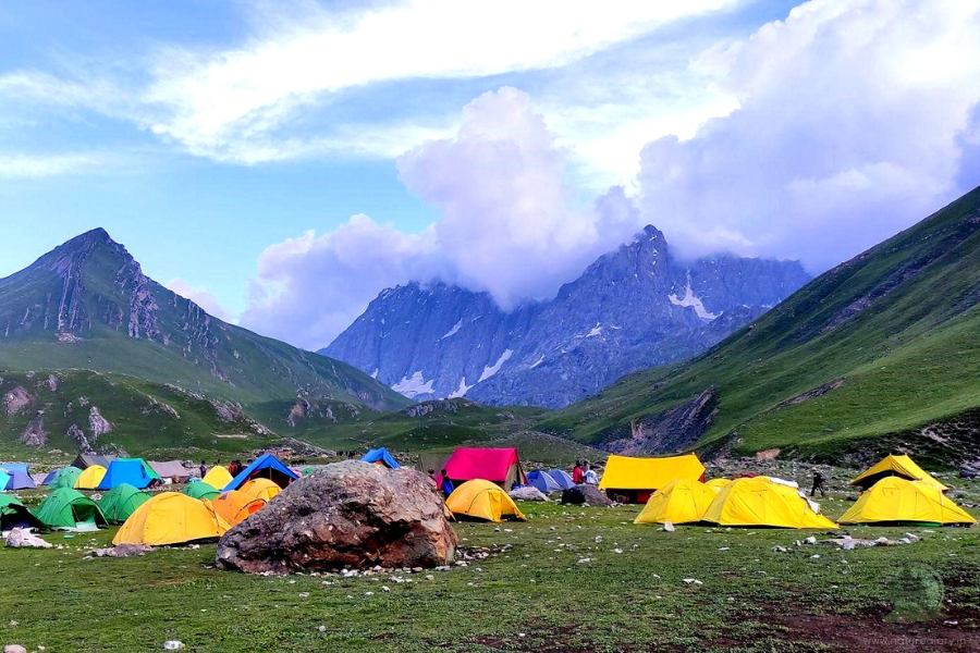
After an hour or so, the rocky floor embraces a green meadow, gradually widening between a couple of ranges. Well, that’s Nichnai Campsite, the destination to pitch the tent on the second day of the KGL trek!
Day 3 (Trek from Nichnai Campsite to Vishnusar)
- Distance: 13.5-14 Km
- Trek time: 7 hours
- Altitude gain: 11,607 ft. to 12011 ft. (Highest Point: 13229 ft.)
On the third day of the trek, you would see the first lake of the KGL trek. This is one of the most happening days, with various landscapes to pamper your views. You must leave the campsite at Nichnai early, around 8 in the morning. Today, you need to cross Nichnai Pass, the first high-altitude pass of the trek at 13,229 ft. With the heavenly beauty of the meadows nestled amidst rugged mountains, undulating plains stretching for miles, and gradual descent into the valley, the day’s going to create memories!
You need to be tactical while navigating through molten ice packs and boulders for the first one and a half hours. Next, the steep climb to the Nichnai pass would give you a tough time. This pass would be visible from the campsite, just adjacent to the snow-clad peaks. Starting with the right bank of the river, trekkers need to cross it and shift to the left bank after an hour. For the next hour, keep to this bank as you ascend the path.
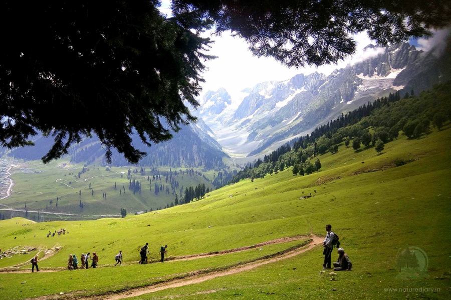
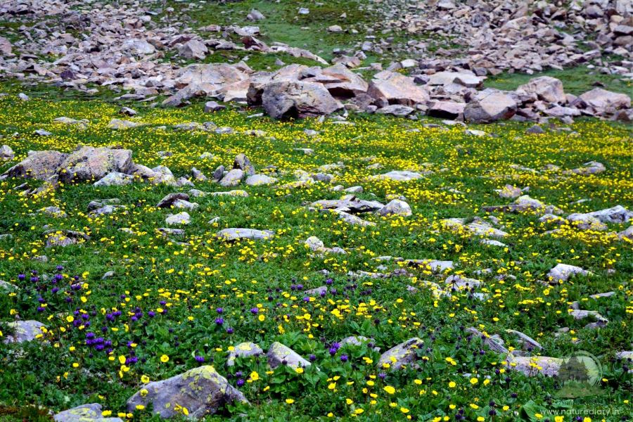
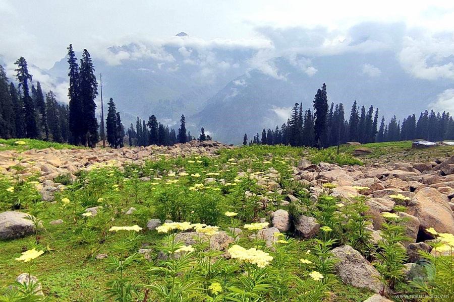
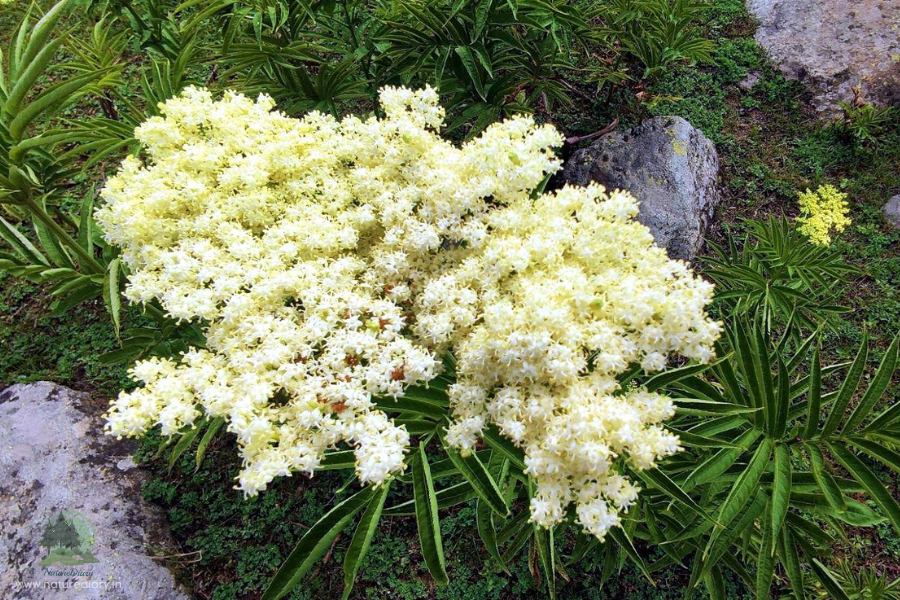
After you cross the pass, you will see the landscape changing. The typical wallpapers on your PC would come alive on the smooth grass. Dotted with yellow wildflowers, the undulating trail of the Kashmir Great Lakes trek would keep your spirits high as you descend.
Trekkers often get an illusion of the Nichnai Pass from the campsite. A rugged ridge is visible from the meadow below. However, this is not the actual pass. Reaching the top of the pass can be hectic, as the trail bends inwards more than once.
The pass is a jagged assembly of rocks, some of which remain scattered over the trail. A long range of snow-covered peaks dominates the views on the left, with ice packs melting on their laps. Although you won’t spot any peaks on the right, the picturesque meadows would enthral your views during the KGL trek.

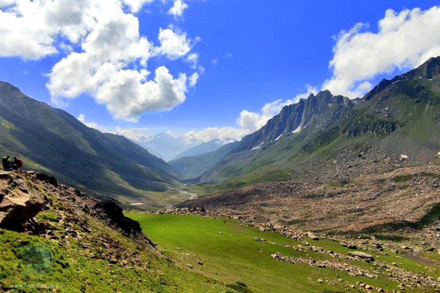
Once you reach the top, the trail jumps sharply from the pass. The rocks disappear from the path, and you would love to return to the pastures. Large flocks of sheep graze in the valleys, with flowers blooming at your feet. The meadows are wide, stretching for several kilometres. You have the mighty mountains on either side while charged-up rivulets cross your path in the meadow.
With the flowery meadows and peaks defining the valley’s charm, you would find yourself in the paradise of the Kashmir Great Lakes. The snow-clad Himalayan mountains remain conspicuous on your left, while the barren heights of the Ladakh ranges show up on the right. You would be trekking through a canvas of grass with lush green views on either side.
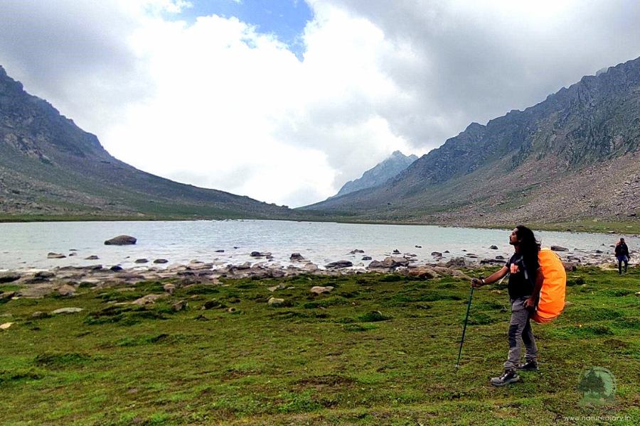
The Vishnusar Lake is not visible from the meadows, and you need to climb around a hundred feet from the campsite. There’s a stream snaking along the meadow from the lake, and you need to keep to its left. Once you pitch the tent, walk for another half a mile along the stream.
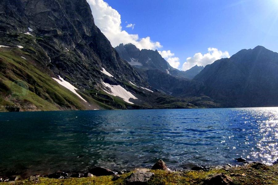
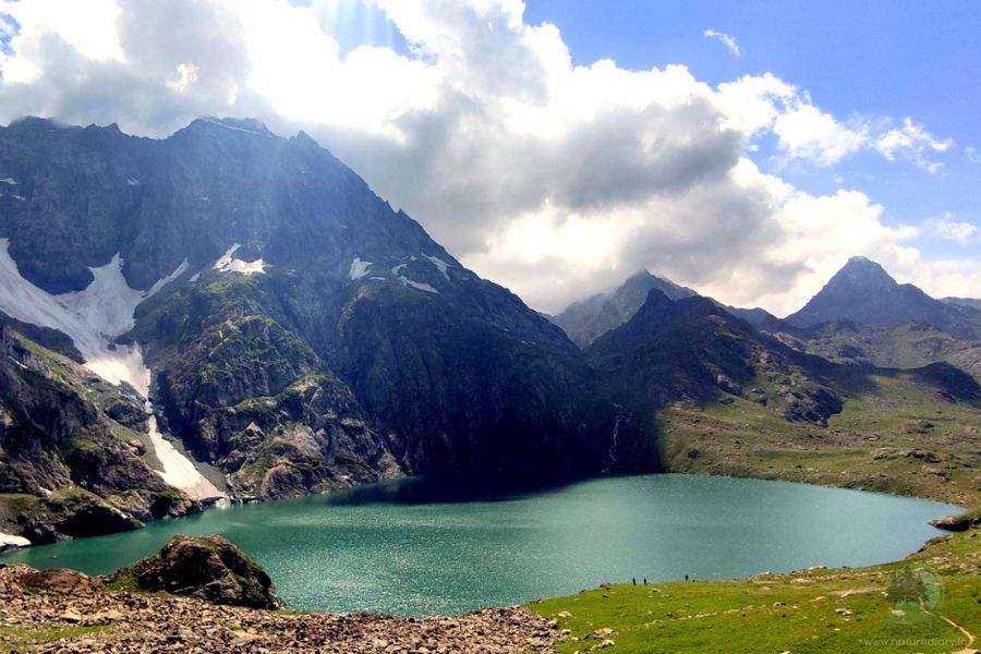
The beautiful Vishnusar Lake sits peacefully between four mountains. It reflects a clear view of the Krishnasar peak, which lies half a kilometre away. The still waters of the lake can picture a splendid view of this peak during the KGL trek. Interestingly, the Vishnusar Lake has cobalt-blue waters, like a typical alpine lake. This is due to the absence of algae, unlike the Gadar Lake, which has a greenish hue.
The campsite at Vishnusar Lake offers splendid views as the day gives way to dusk. With horses grazing along the stream, boulders dividing the flow of the tide, and distant colours of the campsite fading into the evening, you have hours to sit and cherish the peaceful ambience. While the high ranges of the Gadsar Pass dominate your frontal view, you can take a glimpse of the mighty ranges of the Ladakh ranges in the opposite direction.
Day 4 (Trek from Vishnusar Campsite to Gadsar via Gadsar Pass)
- Distance: 16 Km
- Trek time: 9 hours
- Altitude gain/loss: 12,011 ft. to 10,706 ft. (Highest point: 13,800 ft.)
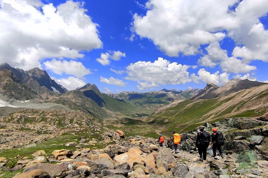
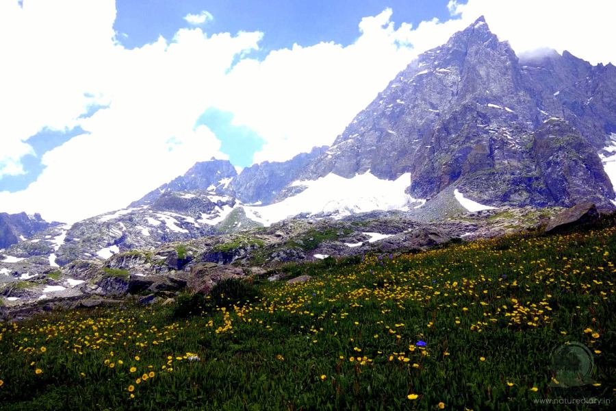
The beauty of trekking on the fourth day lies in the exotic flowers and picturesque lakes nested below the snow-clad mountains. Brace up for the longest march and probably the most hectic day of your KGL trek. On the fourth day, you need to start early from your campsite at Vishnusar, preferably by 7:30. The highest point of your trek awaits your weary presence at 13,800 ft.
The mornings are chilly, and trekkers love photo sessions along the clear reflection of the Krishnasar Peak, casting its reflection on the crystal clear blue waters of the Vishnusar Lake. Behind the campsite, there’s a moderate stretch of boulders. Around 500 ft. above the last camp, you have the Krishnasar Peak, leading to the Gadsar pass further higher.
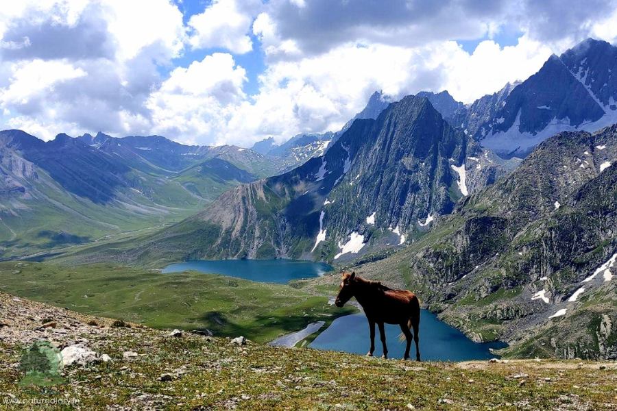
The trail leads you to the other side of the mountain. From the top, you can get a clear view of the azure blue waters of the twin lakes- Vishnusar and Krishnasar. The terrain is moderately wide, although you might feel cramped for space in some areas. Long queues of mules frequently interrupt the trekker’s progress unless the latter takes steep shortcuts.
You can catch the mesmerizing view of the twin lakes for nearly an hour until you reach the trek’s highest point at Gadsar Pass (13,800 ft). It takes nearly 2.5 hours to reach this spot from Vishnasar campsite if you walk at a moderate pace. The ascend is steep, but once you cross the pass, you will love the gentle trot downhill.
Starting early in the morning, trekkers should try to cross the Gadsar pass in the first three hours, as they still have more than an 11 Km downhill journey awaiting them. From the top of the Gadsar Pass, you can actually get a splendid view of five lakes: Krishnasar and Vishnusar at the back, and Gadsar, Yamsar, and another small lake at the front.
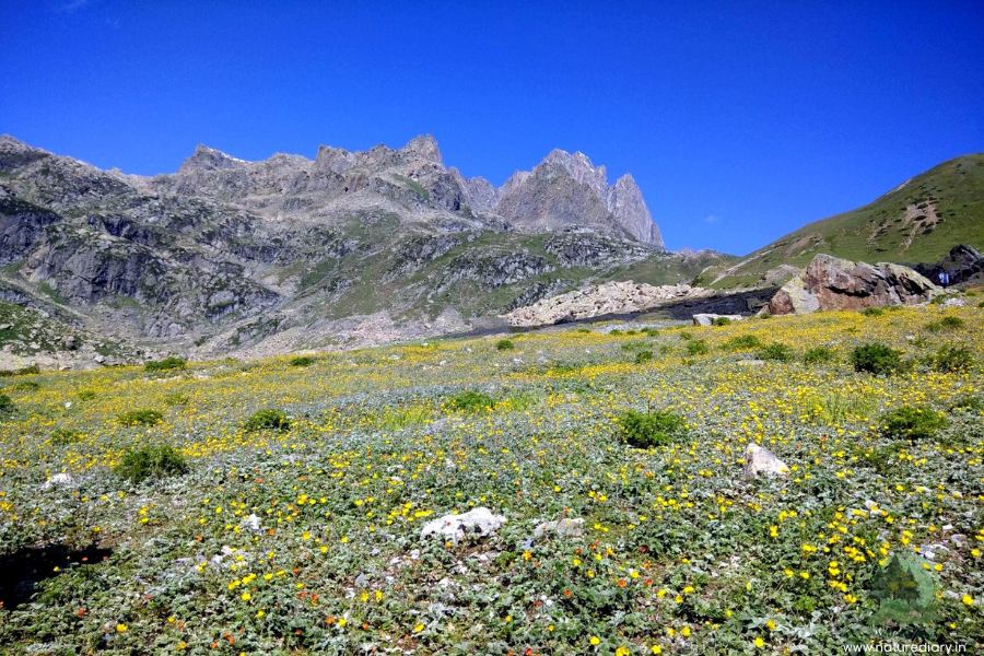
The downhill trek to Kashmir Great Lakes would give you lasting memories, as it is no less than the Valley of Flowers in Uttarakhand. Initially, the descent would be steep, followed by a gentle walk down the meadows. While you let your vision feast on the yellow, purple (Iris), and red flowers in the valley, the snow-clad peaks compose a perfect wallpaper in the backdrop. Even in the middle of July, you can find snow along the downhill trail on the other side of Gadsar Pass in the KGL trek.
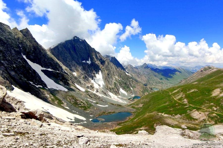
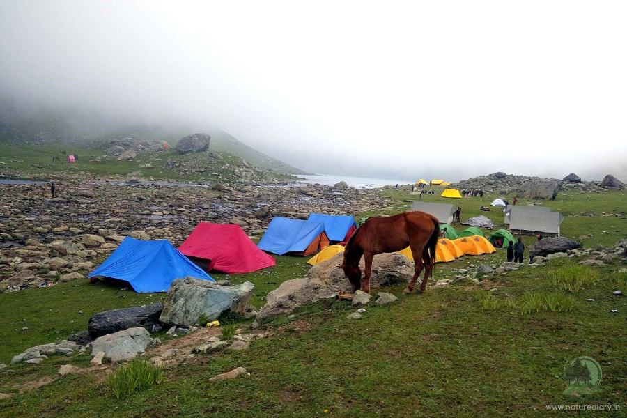
After descending for an hour, you would land in the gentle meadows with flocks of sheep once again. The valley narrows up, and you would find ranges on both sides. Further marching downhill, you will come across Gadsar Lake (12,500 ft), the last of the three lakes you had seen from the top of Gadsar Pass. The lake has a green tinge on its surface, unlike the last two lakes, due to the presence of algae. This green layer, along with the rolling meadows and snow-clad cliffs surrounding it, is a paradise for photographers.
However, you need to pitch the camps further down the valley, close to the Army Camp. This abandoned army shelter lies another hour downhill, and the last stretch might take a toll on your ankles. The landscape looks pretty, just like a large green bowl of grass sitting between the green mountains. A stream trickles down the valley, connecting the three lakes.
Further down, you would come across what we call a ‘horseshoe bend’ of a stream before you reach the army camp. After verifying your identities, the Army personnel would allow you to go through the camp and pitch your tents.
Day 5 (Trek from Gadsar to Satsar Lakes)
- Distance: 11.5-12 Km
- Trek time: 5 hours
- Altitude gain: 10,706 ft. to 11,985 ft.
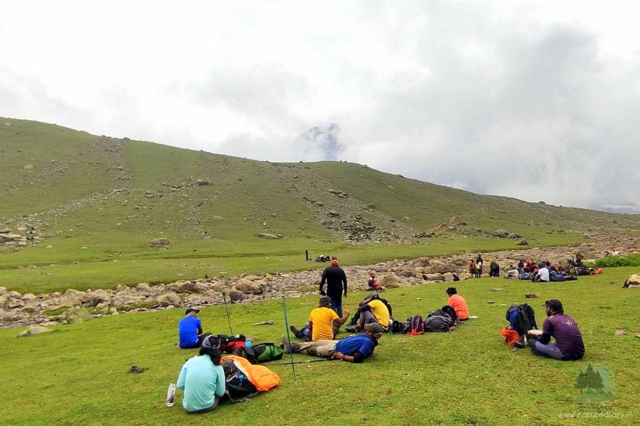
The pleasant views of a stream welcome trekkers as they set their way on the fifth day for Satsar Lakes. This is a collection of as many as seven different lakes. However, you can view only four or five of these if weather permits, as the other great lakes are located on the other side of the cliffs.
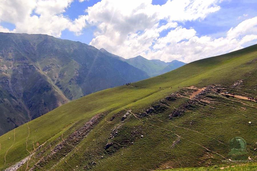
Prepare yourself for a steep ascend lasting for 1.5 hours after you cross the stream. As you gain altitude, you would find the stream narrowing down to just a glittering line far below. It’s easy to find the trail leading uphill after you cross the stream. While you can see the treeline below, the vegetation mostly consists of grass and small bushes. After reaching 11,500 feet, the trail would take you through a traverse.
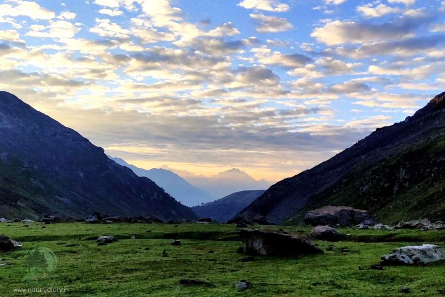
Next, you can get a glimpse of POK as the trail takes you to the flat plains. Surrounded by mountains, the meadows look blissful with rolling turf on their surface. A few isolated mountains stand in front of you. A stream trickles through the flat lands, and you need to trek further down.
The tricky part of the journey lies in navigating through the boulder zone after the first of the Satsar Lakes becomes visible. The weather mostly remains cloudy here due to the geographical location of the lakes. A few showers with lightning are not uncommon in this region of the KGL trek.
On the fifth day, the beauty of the trek lies in the distant mountains enveloping the clouds and the long stretches of flat lands with wildflowers. After you cross the bend from where you can view POK, a flat table-like landscape emerges at the backdrop, resembling the Windows 98 wallpaper.
After pitching the tent in the valley, you would have hours for the sunset to come. So, make the most of these moments and try to see as many lakes as possible during the Kashmir Great Lakes trekking.
Day 6 (Trek from Satsar Lakes to Gangabal via Zaj Pass)
- Distance: 9 Km
- Trek time: 6 hours
- Altitude gain/loss: 11,985 ft. to 11,486 ft. (Highest point: 13,276 ft.)

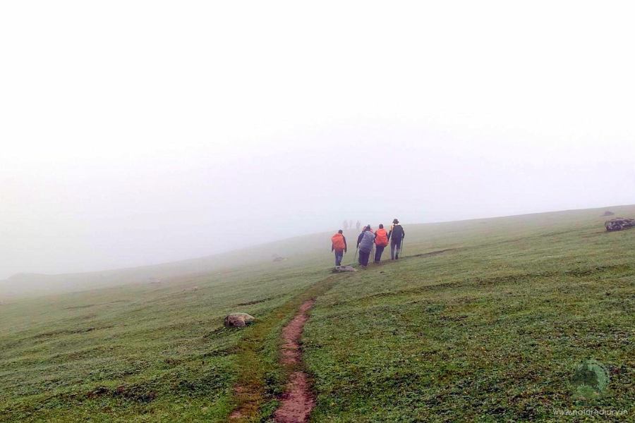
In terms of skills required, the sixth day of your Kashmir Great Lakes Trek will be the most challenging. A long boulder zone awaits you just after you leave the campsite in the morning. This would be an acid test for trekkers, particularly when you trudge through the uneven boulders. It would take around 1.5 hours to leave the Satsar Lakes behind.
Next, you would just touch the treeline before taking on a steep climb for the Zaj Pass (13,276 ft.). Altogether, this is the day to test your mental and physical stamina! This would actually be a boulder-hopping journey, and then the trail would go downhill for half an hour.
The ridge line visible from the tree line is around 1,000 feet high. On gaining this height (starting from 11,800 ft.), you need to zig-zag your path to the first ridge at the beginning. It would take around an hour to get to the top of this ridge. Once you reach here, you will find a couple of other ridges further up. The upper part is rocky and barren. As you gain altitude, you will appreciate the contrasting views of the greenery behind and the rugged barrenness ahead.
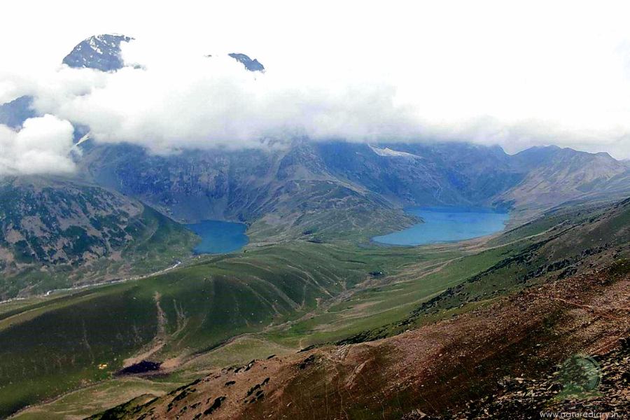
Reaching the third ridge would take more than two hours. This is the top of the Zaj Pass, and you would get a surprising view of Mount Harmukh, which is believed to be the abode of Lord Shiva. The twin lakes of Gangabal and Nundkol lie at the feet of Mount Harmukh. If you are lucky, you will get a crystal-clear view on a cloudless day!
This view of the twin lakes is one of the most striking scenes of the KGL trek. These two lakes are connected by a stream and lie adjacent to one another. On the right, the lake you see is Gangabal, while the other one is Nundkol.
Well, the destination for your camp is 1,400 feet below, so you know how sharp the descent should be. The stony path is full of loose rocks and large boulders, so take care of your footing. Most trekkers pitch their camp beside Nundkol Lake.
While you descend, take photos of the natural stone formations with green algae and vegetation, adding a mystic essence amidst the clouds at the backdrop. On the way, you would come across a charged-up stream sonorously making its way through the boulders. Fill your bottles if they are empty and make a steep descent to reach the green pastures again.
Well, this is a great place to have your lunch, as a short ascent awaits you before you can finally descend and reach the campsite. Lake Nundkol and Gangabal are favourite weekend destinations for local Kashmiris near Kashmir Great Lakes. So, it’s common to find them pitching their tents beside yours. These people are very friendly, and it would be a pleasure for you to experience the typical Kashmiri lifestyle.
On the rocky edges of the Harmukh, you can spot glaciers hanging. Trout fishing is a popular activity in both these lakes and the narrow stream connecting them. After pitching your tent, it would take around half an hour to trek to Gangabal Lake on the other side of the rocks. There’s a solid bridge close to the lake, so you need not risk yourself getting wet while trying to cross the stream on logs.
Day 7 (Trek from Gangabal Lake to Narnang and Drive to Srinagar)
- Distance: By trekking 13 Km and driving 52 Km
- Trek time: 6 hours
- Altitude loss: 11486 ft. to 7800 ft.
Well, they say nothing ends until it actually ends! The last day of your Kashmir Great Lakes Trek would probably strain your ankle or calf muscles or even break your toes if you aren’t habituated to steep down treks. Loose rocks and narrow trails further make the descent challenging. Moreover, mules and horses carrying luggage often get stuck or topple over the sharp bends downhill, unable to keep their balance. Therefore, navigating through this stretch is going to be a challenge.
Start early in the morning, preferably by 6 AM since a thorough luggage check session awaits you at the army camp. There’s a narrow log bridge (not more than a foot wide) over the stream connecting Nundkol lake to Gangabal Lake. After crossing this stream, take the trail through the tree line, keeping to the ridge at the right. After one hour or so, you would reach the army camp, and the verification process might take more than a couple of hours. This is why it is recommended not to schedule the flights on that day itself.
Sitting at the army camp, look at Harmukh peak if the sky is clear. However, photography by mobile phone, DSLR or drone camera is strictly prohibited at the army camp. Meanwhile, you can catch the phone tower here after 7 days of the KGL trek, so call home to inform them that you are doing great!
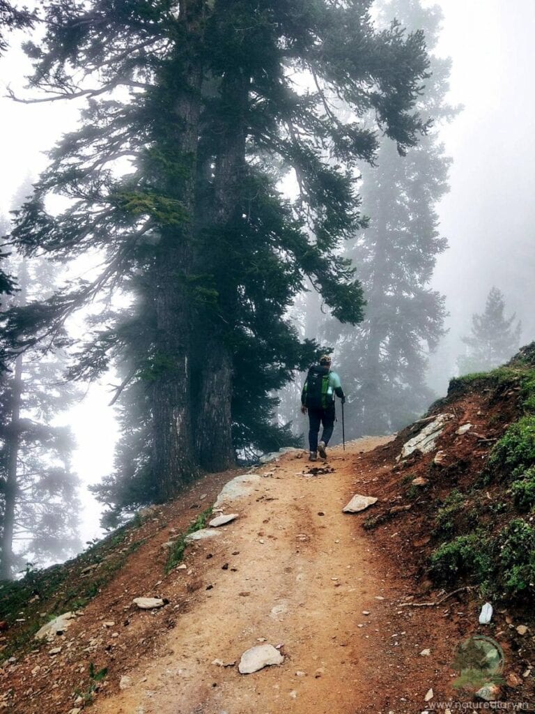
Well, the beginning of the pine tree lines marks a significant descent, and you would soon be getting back to civilization. Keep to the right without venturing into the forest; otherwise, you can lose your path. On the last day, the vegetation would be quite different from whatever you had seen throughout the trek. Tall pines, misty trails, and meandering boulder paths resemble typical cloudy hill stations of India.
The actual descent begins after you trek 60% of the path on the last day. Brace up for a really steep descent through the muddy paths. Remember, you would be descending more than 3,000 ft. in the last 4 Km. So, you know how badly your toes might ache! The last stretch to Narnag would test your tenacity and endurance, as you can now see the civilization, yet the path seems never-ending.
Well, if you find yourself on the uneven stone track of the adjacent village, comfort your feet that Naranag is not far away. Once you get to the main road, don’t forget to take a selfie along with the hoarding welcoming you to the KGL trek.
How Much Does Kashmir Great Lakes Trek Cost?
While calculating the cost of the Kashmir Great Lakes Trek, you need to factor in the cost of food, accommodation in tents, and the fees of your guide. Generally, you should be able to complete the trek within ₹12000 to ₹15000. If you want to offload your luggage, be ready to shell out ₹400-₹500 extra daily to the porter.
Although there are several reputed organizers for the KGL trek, I highly recommend Himalayan Passion for their excellent arrangements and professionalism during my trip. Not only Kashmir Great Lakes, but Himalayan Passion also arranges various treks in Uttarakhand, Himachal Pradesh, Sikkim and West Bengal.
Activities During Kashmir Great Lakes Trek
Treks are loaded with adventures and activities. While we won’t recommend you wander away from the main trail, here are some activities you might try on the KGL trek.
Things to Carry during KGL Trek
- Documents: Among all trekking essentials for the KGL trek, documents are the most important. Carry the original and Xerox copies of the Aadhar card or other photo ID cards issued by the government. Also, you would need a medical certificate validating your fitness issued by a practising doctor for trekking to the Kashmir Great Lakes.
- Trekking Shoes: Considering the rugged terrain on KGL Trek, you would need the comfortable and waterproof trekking shoes capable of walking on snow. Ensure proper ankle support and grip since you would cover long distances, including boulder sections and muddy terrains.
- Rucksack or Trekking Backpack: Get a backpack of 50 to 60 litres with good shoulder and hip support. The pockets should be quickly accessible. Thus, choose a water-resistant rucksack with rain cover since there is a possibility of a shower at any time.
- Clothes: While going for the KGL trek, you need at least three to four layers. So, carry 3 synthetic T-shirts, 2 light fleece jackets, 1 full-sleeve sweater, and a waterproof outer layer like a jacket. 2 trekking trousers would be adequate. Don’t miss out on your sun cap, woollen cap, synthetic gloves, socks (3 pairs), sunglasses, and sunscreen.
- LED Torch or Headlamp: Since no electricity would be available throughout the trek, it would be wise to carry your LED torch or headlamp. Make sure to carry enough batteries so that they last 7 days. We recommend a headlamp since it would keep your hands free, whether you pack your bag inside the tent or visit the toilet tent.
- Other Accessories: Carry other necessary accessories like a power bank, sanitiser, soap paper, wet wipes, and a raincoat. Also, carry trekking poles, binoculars, insect repellants, medicines, water bottles, lunch boxes, and reusable plastic bags. You don’t have to worry about tents or sleeping bags as the tour operator facilitates them.
Tips For Trekking to the Kashmir Great Lakes
Frequently Asked Questions (FAQ)
The Kashmir Great Lakes Trek has a moderate to challenging level. Although the pictures look beautiful, you need to toil your way through the trek. The factors making it a tough trek include the long distances each day (12-16 Kilometers), a considerable gain in altitude, and three high-altitude pass crossings.
Yes, the KGL trek is absolutely safe. It is away from the border areas and disturbances. The trek lies in the Sonmarg region, which attracts lots of tourists. Besides, the trekking trail has as many as 3 army camps. You would be camping close to these camps, which makes the trek safe.
In 7 days, you need to cover around 75-80 Km. Therefore, on average, you would be trekking around 9-16 Km each day.
You can cherish as many as 6 alpine lakes in the KGL trek. Apart from these, you can try and find some of the smaller lakes along the trail.
Yes, Kashmir Great Lakes Trek is one of the most diverse and picturesque treks in India. If you can make it, you should consider yourself lucky to witness the pristine waters of the lakes, rolling meadows, high-altitude peaks, and snow-clad mountains.
Trekkers usually go for KGL from July to mid-September. Heavy snowfall keeps the trails buried during the other seasons. Although the rest of the country, and even Uttarakhand, experiences monsoon during these three months, this is the ideal time for trekking the Kashmir valley. Thanks to the Pir Panjal Range, Kashmir remains in the rain shadow side as it blocks the clouds from Uttarakhand. Nature bursts into bloom, although you can spot melting ice caps all around.
Kashmir Great Lakes Trek is a high-altitude trek. So, you need to carry your tents and other necessary tools to pitch them. Starting from Shitkari, you would pitch these tents in the respective campsites each day until you reach Gangabal. No other accommodations, such as hotels or homestays, are available amidst the wilderness.
Generally, the trek organizers provide wholesome meals during breakfast, lunch, evening snacks, and dinner. They also supply dry fruits and chocolates. Trekkers can also carry cashews, almonds, nuts, raisins, and dry foods on their own. Chapatis, rice, bread, cornflakes, vegetables, rajma, dal, sweet dishes, and milk are available with most of the trek organizers. All supplies must be carried on mules or horses, along with other cooling accessories and gas cylinders.